Zoning
Planning Board
The Planning Board is appointed by the Village Council. On July 9, 2018, the Zoning Ordinance was updated to combine the Planning Board and Board of Adjustment. Five alternates were appointed. The Planning Board is enabled to act as the Board of Adjustment when needed.
The Planning Board is charged with developing and maintaining a continuing cooperative long-range planning program to benefit the residents of the Village of Misenheimer. They also hear requests to change the Zoning Map, Zoning Ordinance text changes, and make land use recommendations. The Planning Board is a recommending Board and all recommendations are forwarded to the Village Council for final decision.
The Planning Board acting as the Board of Adjustment makes decisions on requests for variance from the Zoning ordinance. The Board also makes decisions on appeals to decisions made by the Zoning officer. These decisions are final and may only be appealed through the courts.
Members of the Planning Board are:
Jeff Watson – jwatson@villageofmisenheimernc.gov – Phone: 704-463-0432 (Term ending 6/30/29) Chairman
Jon Byers – jbyers@villageofmisenheimernc.gov – Phone: 336-466-5476 (Term ending 6/30/28)
Lane Peeler – lanepeeler@msn.com – Phone: 704-850-0035 (Term ending 6/30/28) Vice-Chairman
Jamie Hammill – jhammill@villageofmisenheimernc.gov – Phone 267-253-8068 (Term ending 6/30/27)
Pete Schoch – pete.schoch@pfeiffer.edu – Phone 734-945-2280 (Term ending 6/30/27)
ALTERNATES:
Seth Cain – 1st Alternate (Term ending 6/30/27)
Ahren Burrage – 2nd Alternate (Term ending 6/30/27)
Pat Wagoner– 3rd Alternate (Term ending 6/30/29)
Sean Webster – 4th Alternate (Term ending 6/30/27)
Michael “Frizbee” Herron – 5th Alternate (Term ending 6/30/27)
For information about Zoning: Dial 704-986-3665 – Bailey Cline – Stanly County Planning Department
For information about the flood plain and flood insurance: Dial 704-463-3001 – Chief Markus Lambert or email chief@villageofmisenheimernc.gov
Zoning & Subdivision Ordinances
An Ordinance of the Village of Misenheimer, North Carolina, as set forth in the code of ordinances of the Village of Misenheimer regulating the uses of buildings, structures and land for trade, industry, commerce, residence, recreation, public activities or other purposes, the size of yards, courts, and other open spaces, the location, height, bulk, number of stories and size of buildings and other structures, the density and distribution of population, creating districts for said purposes and establishing the boundaries thereof: defining certain terms used herein: Providing for the Method of administration, amendment and enforcement: providing penalties for violation: Providing for a Planning Board and a Board of Adjustment (or for the Village Council to act in that capacity) and defining the duties and powers of said Board: repealing conflicting ordinances: and for other purposes. BE IT ORDAINED By the Village Council of the Village of Misenheimer, North Carolina, as adopted on September 8, 2014 and effective on September 9, 2014 and listed as follows (Click Articles):
ZONING ORDINANCE TABLE OF CONTENTS
ARTICLE 1 – AUTHORITY AND PURPOSE
ARTICLE 2 – APPLICABILITY OF ORDINANCE
ARTICLE 3 – ESTABLISHMENT OF ZONING DISTRICTS
ARTICLE 4 – GENERAL REQUIREMENTS
ARTICLE 5 – ADDITIONAL CONDITIONS FOR CERTAIN USES
ARTICLE 7 – OFF-STREET PARKING AND LOADING
ARTICLE 9 – LANDSCAPING, SCREENING AND BUFFER AREAS
ARTICLE 10 – NONCONFORMING USES
ARTICLE 12 – PLANNING BOARD ACTING AS BOARD OF ADJUSTMENT
ARTICLE 13 – RULES OF CONSTRUCTION, INTERPRETATION, AND DEFINITIONS
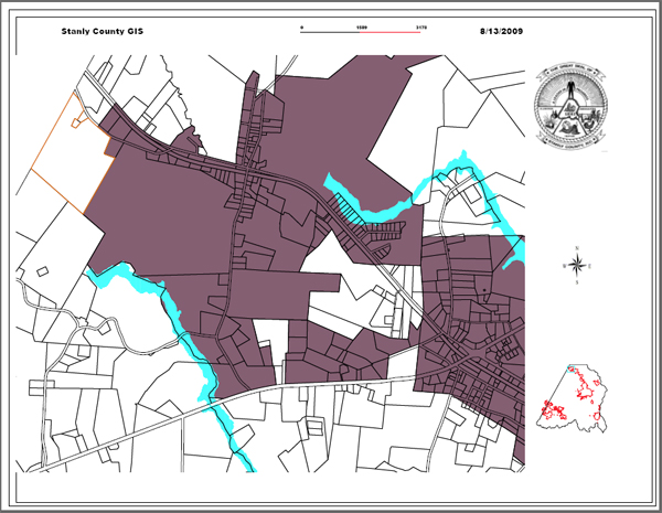
Zoning Map
The Zoning Map is color coded to indicate the type of zoning in effect for each property within the Village of Misenheimer. To view this map, click below.
Flood Damage Prevention Ordinance
Click the Flood Damage Prevention articles for the details:
ARTICLE 1. STATUTORY AUTHORIZATION, FINDINGS OF FACT, PURPOSE AND OBJECTIVES.
Flood Plain Map
Land Use Plan
The Land Use Plan is a conceptual document which describes the desired outcomes of Village zoning. The Zoning Ordinance must be consistent with this document.
Comprehensive Land Use Plan
A Land Use Plan to Fit Our Vision of Ourselves
Misenheimer is a community that developed in the company of tourism and education.
Once a stop on a railroad spur that served a nearby early tourist destination,
Misenheimer Springs, the place drew the interest of the Mitchell Home School as it
sought a new location. By 1910, when the Mitchell Home arrived, industries such as
mining had largely disappeared from the area. Agriculture, tourism and education
remained, alongside a slowly but steadily growing residential community. Since then,
education has been the major industry of the locale, as Mitchell Home evolved into what
is now Pfeiffer University.
The forces that drove development in much of the rest of the state and county have long
ignored this quiet corner of Stanly County. This appears to be changing. As upcoming
major enhancements to NC Highway 49 and US Highway 52 invite the prospect of more
traffic and the beginning of commercial development in our community, we sense the
need to take some measure of control over our own environment. Change will come,
but it can be managed in an orderly direction for the benefit of all.
We, the citizens of the Village of Misenheimer, have a shared vision of ourselves as an
educational, residential, agricultural, and family-friendly community. We recognize the
desirability of industry and commercial activity to provide livelihoods for our adult
population, and for our children as they grow. We are steadfast, however, in our belief
that any industries welcomed into our midst must be compatible with our primary
characteristics. Education, agriculture, recreation and tourism remain high on our list of
desirable industries. Enterprises that are compatible with our residential nature are
welcome. All such endeavors need to be chosen and physically placed in a manner that
protects and enhances our quiet residential, educational character, and preserves the
scenic beauty of our community and its surroundings.
Existing Conditions
• We share a future alongside our sister city, the Town of Richfield. Not only are we
joined geographically, we are also intertwined by generations of shared family, friends,
churches and civic activities. Together, and in concert with one another, we can
promote a brighter future for our shared northern corner of Stanly County.
• The nearby intersection of NC Highway 49 and US Highway 52 is destined to become
a focal point of growth. With physical construction of a major improvement to Highway
49 now just 10 miles away in Mt. Pleasant, the completion of a 4-lane divided highway
from the growing metropolis of Charlotte all the way east to the Yadkin-Pee Dee River is
no longer a dream, it is quickly becoming a reality.
• Misenheimer is a part of the Uwharrie Lakes Region. With close proximity to the water,
we will be impacted by the tourism and recreation attractions created by the lakes
themselves, the Uwharrie National Forest, Morrow Mountain State Park, and even the
North Carolina Zoo in Asheboro.
• A centerpiece in our community is Pfeiffer University. By offering high quality
education in a wide choice of disciplines, not only does it draw a diversified student
body from many places both inside and outside of North Carolina, but it also offers to
the community at large the opportunity for exposure to a variety of cultural and sporting
events that enrich us all. Pfeiffer’s commitment to education has led to the creation of
the Gray Stone Day School (6-12), placing the opportunity for academic excellence
within walking distance of our youth. While already proving to be an engine for job
growth in the county, the possibility of a cooperative sharing of its resources with clean
and compatible new industries seeking a home makes Pfeiffer University unique, and a
jewel in our community’s midst.
• The framework from which we build is the existing physical infrastructure within which
we live, work, worship, relax and commute. The homes, churches, roads, institutions
and scenic green spaces are the handiwork of those who came here before us, and the
contributions continue today at the hands of the community’s current residents and
property owners. Taken as a whole, this infrastructure deserves to be protected as it is
and enhanced, not harmed, as we build on the foundation given to us. Along with our
people, this is what gives our Village its special charm and attractiveness.
• Our most important asset is our people. Their industry and ingenuity, dedication and
cooperative spirit are what keep alive what otherwise would only be physical structures
placed on nature’s backdrop. Our people, too, are to be protected and nurtured. When
they return from their labors or from socializing, they deserve a healthy place of peace
and rest. Today, our air and water are clean. Our audible environment is filled with the
sounds of nature, without unpleasant interruption. Our visual environment is one of
scenic winding roads and an abundance of open, green space. Our citizens deserve to
have a refreshing place to return to, and to share with others: A place called “home”.
Long Range Planning Recommendations
The Land Use Plan is charged with the responsibility of taking into account what has
gone on before and what exists today, and then making estimations and judgments
about what may happen in the future. No one person or very small group of people can
have the wisdom to know what the future will actually bring, but by soliciting comments
from a wider group, a consensus opinion can be formed about what likely future
developments will be, and about what guidelines would be appropriate to affect those
developments.
The inputs received from citizens on recent matters of local development
speak to the fact that growth is inevitable. The desire of our citizenry is
to manage for desirable growth. The Land Use Plan constructed will, by
design, be a guide to future development so that Misenheimer’s provincial, educational,
cultural and peaceful community character is not lost to the gradual, insidious effects of
incompatible uses and over-development.
Guidance, as provided by this comprehensive Land Use Plan, is intended to be a
reference for our citizens and for public officials or developers who seek to make
modifications to the Zoning Ordinances of the Village of Misenheimer. The entire
document is founded on the Principles listed below:
Village Land Use Planning Principles:
1.Guide future growth and development to be compatible with existing uses. The
citizens and entities within Misenheimer have a symbiotic relationship. We have grown
accustomed to the quality of life that has evolved here and we seek to preserve it for
both ourselves and for future generations to enjoy. A central theme of our Land Use
Plan revolves around this preservation.
2. Enhance the provincial, residential and educational appeal of areas of our Village that
already possess such, and nourish new potential areas. Misenheimer has evolved as a
rural residential educational enclave. It is the expressed vision of the Village to preserve
and to actively enhance the characteristics that make Misenheimer what it is.
3. Focus commercial or industrial development along highway corridors as they exist or
develop. Two major highway projects will impact our Village as it seeks its place in a
developing world. It is the vision of the Village, as these changes unfold, to use these
transportation corridors as the proper placement for economic development. Doing so
will ensure that transportation infrastructure is readily available for such development
and that such development will disrupt quality of life in the Village as minimally as
possible.
4. Promote an active, vibrant, interactive community where residents can cross paths
and meet their neighbors as they go about their lives within the Village. As Misenheimer
grew, intertwined with Pfeiffer, a varied mix of traffic has evolved to move residents
around the community. This mix of pedestrian, bicycle, and vehicular traffic has served
to make us what we are. The Village seeks to accommodate and promote this mix of
traffic modes.
5. Create public spaces in which the community can gather and enjoy recreational
opportunities. In order to fulfill our desire to place recreational facilities at the disposal of
our citizens, we need places where individuals can come together and enjoy common
pursuits. We need parks or similar spaces in which to gather, exercise, play and
compete. These sites should be varied in size, function, and location in order to fulfill the
assorted tastes of our diverse population. The Village should seek over time to create
more public places and social gathering places which ought to be scattered in various
neighborhoods throughout the Village.
6. Promote development and traffic patterns that keep pedestrians and cyclists safe as
they move about the Village. Efficiency and leisure can both be part of traffic flows if
some forethought is applied. Pedestrians and cyclists today move about the Village
without undue fears for their safety. As growth adds to the vehicular traffic that moves
about and throughout the Village, accommodations should be made to retain the mix of
traffic modes. Sidewalks will be encouraged in and around new development and added
as an amenity in existing neighborhoods. Continuing the theme of community
interaction, sidewalks, bicycle paths, and pedestrian-friendly / bicycle-friendly traffic
laws are envisioned to promote these environmentally friendly traffic modes, and to
keep leisure traffic safe and enjoyable. At the same time, vehicular traffic should be
routed so as to minimize traffic flows through residential and institutional areas while at
the same time concentrating and moving efficiently traffic intended for commercial
purposes. Wherever possible, there should be a separation of leisure traffic from
commercial traffic.
7. Buffer well the residential and educational portions of the Village from commercial
and/or industrial development. Quality of life is a major theme in Village land use
considerations. Strict, failsafe buffering of places of worship and residential or
educational facilities from commercial/industrial development endeavors is essential.
While recognizing the need for commercial and industrial development as a financial
resource for the strengthening of our community as a whole, those developments with
the highest impacts on ambient sights, sounds, odors, traffic or other quality of life
features should be located as remotely as possible from residential or
institutional/educational so as to decrease the impact on quality of life.
8. Provide for appropriate retail development, as it becomes necessary and desirable.
This principle is a nod to our recognition that change is inevitable. As the community
grows and evolves, we may want or need retail development and restaurants near to
where we live. The Village should work to wisely implement such development as the
need and/or opportunity arises. The addition of public sewer service along the Highway
52 corridor would improve the likelihood of economic development and would ensure its
proper placement on a major transportation corridor.
9. Promote sound and sustainable agricultural practices rooted in the values and
traditions of successful family farming. The family farm is one of the most basic building
blocks of a healthy society, and is to be encouraged and nurtured when operated on a
scale that has minimal impact on its neighbors. Successful agricultural practices should
embody good sanitation, sustainable production, neighborly consideration, and
environmental soundness. Practices should contribute to air, water, and soil quality,
while at the same time should not negatively affect the sights, sounds, or odors
experienced by immediate neighbors or the Village as a whole. Agriculture of this nature
will enhance the aesthetic value of our community’s environment.
10. Value Misenheimer’s unique cultural and educational resources, and manage
development accordingly in order to preserve Misenheimer and its singular identity. We
should not forget the forces that cajoled us to incorporate. The awakening to the fact
that Misenheimer was, and is, a special place worth preserving and protecting has led
to a self-examination of all that we are and all that we can be. Few communities of our
size and rural location can claim the educational and cultural facilities that we have in
our midst. This special “something” that we have extends beyond mere buildings. The
fruits of those facilities, be they homes or churches or other institutions, lie within the
people who have passed through them, whether they remain here with us or have
become an extended arm of Misenheimer reaching out into the wider world.
11. Preserve, wherever possible, the Village’s historical properties, structures, records
and traditions. History is what has led us, as a community, to be what we are. In order
to be truly informed, citizens should recognize that education relies on awareness of
the past. Historic structures and properties can serve as anchors to remind us of the
things we value and why, as well as to keep us mindful of those mistakes which we
ought to avoid repeating. Historic records can serve the same purpose and may be the
sole remaining evidence of things or places lost to the sands of time. Tradition can be
an emotional link to those who have come before and have led us here. If we believe
what we value now is worth saving, promoting respect for our past serves to reinforce
that judgment.
12. Grow the Village to serve as a pleasing, viable home to its residents and entities,
and as a destination for educational opportunity and tourism. A final admonishment from
the body politic is to grow the Village as a sustainable project. It should, over time,
provide a sustainable economic engine built on education, quiet tourism and green
industry. We envision a destination at which those yearning for respite, enlightenment
and knowledge can assuage themselves with the amenities of both Pfeiffer University
and the Village of Misenheimer. Those who come will also find healthy, vibrant industry
and commerce that complements and serves the friendly place that we want to grow.
The above principals and recommendations reflect the conditions and aspirations
present at the time of this writing. The passage of time brings with it changes in
circumstances, and thus the Land Use Plan should be reviewed and updated on an
every 10 year basis. More frequent updates and changes could lead to policies and
guidelines that come and go with the wind. Less frequent updates run the risk of falling
behind the times. However, the basic Principles embodied in this document should live
on from Plan to Plan to ensure that Misenheimer lives up to its motto of “Preserving the
Future”.
August 17, 2003
Reaffirmed April 13, 2009
Reaffirmed February 9, 2015
Updated and Amended August 8, 2022
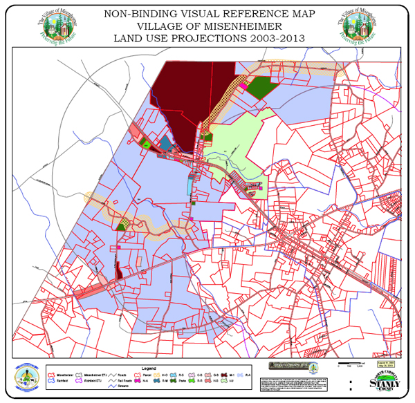
Land Use Planning Map
The Land Use Planning Map is non-binding and presents a conceptual look at how the Village might be zoned in the future. This map must be consistent with The Land Use Plan. To view the Land Use Planning Map, click here. A PDF file is located at the bottom of the map if detailed viewing is desired.
Special Use Permit Application
Miscellaneous Fee Schedule
Watershed Protection Ordinance
Animal Control Ordinance (pdf)
Brunch Bill Ordinance (pdf)
Budget Ordinances & Memos
Charter Amend Ordinance (pdf)
Noise Ordinance (pdf)
Public Nuisance Ordinance (pdf)
Mailing Address
PO Box 100
Misenheimer, NC 28109
Phone Number
704-463-1234
Fax Number
704-463-1107
Office Hours
manager@villageofmisenheimernc.gov